


Le Mont Dieu

Tommy Eric
User
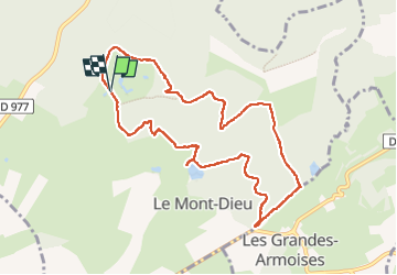

Length
9.5 km

Max alt
291 m

Uphill gradient
281 m
Km-Effort
13.2 km

Min alt
185 m

Downhill gradient
282 m
Boucle
Yes
Creation date :
2025-04-08 11:48:06.373
Updated on :
2025-04-08 15:19:45.023
3h31
Difficulty : Difficult

FREE GPS app for hiking
 SityTrail
IGN / Geographical institutes
SityTrail Plus
The world is yours!
About
Trail Walking of 9.5 km to be discovered at Grand Est, Ardennes, Le Mont-Dieu. This trail is proposed by Tommy Eric.
Description
rando avec Pierre, Philippe, Eric, Guy
Positioning
Country:
France
Region :
Grand Est
Department/Province :
Ardennes
Municipality :
Le Mont-Dieu
Location:
Unknown
Start:(Dec)
Start:(UTM)
634829 ; 5489848 (31U) N.
Comments